
Zimbabwe Fly-In Safari — Hwange, Chobe & Victoria Falls Field Intelligence
Three ecosystems. Three geological identities. One itinerary that explains why Africa's greatest wildlife concentrations happen exactly where they do.
Wild by Nature. Africa by Choice.
Most travellers who book a Victoria Falls, Hwange, and Chobe safari think they are choosing a route. What they are actually doing — whether they know it or not — is crossing three entirely distinct geological systems, each with its own hydrology, soil chemistry, and wildlife logic. Understanding that distinction is the difference between watching animals and understanding why they are standing precisely where they are.
This is not a scenic loop. It is a field intelligence masterclass in the mechanics of African wildlife survival.
Here is how the three destinations in this itinerary compare across the field intelligence criteria that matter most to a serious safari traveller.
| Feature | Victoria Falls | Hwange National Park | Chobe National Park |
|---|---|---|---|
| Geology | Basalt lava plateau | Kalahari Sand — fossil lake bed | Alluvial clay floodplain |
| Water Source | Zambezi River — permanent | Solar-pumped boreholes — managed | Chobe River — permanent |
| Wildlife Driver | Geological spectacle — gorge system | Borehole hydrology — predictable predator orbits | Soil fertility — highest elephant density on Earth |
| Signature Experience | Gorge geology from the air — microlight and helicopter circuits | Underground water-level blind — elephant mechanics at eye level | River safari — elephant river crossings and buffalo floodplain herds |
| Best Activity | Flight of Angels circuit — Batoka Gorge | Dawn game drive to Ngamo Plains pans | Morning boat safari — Chobe riverfront |
| Peak Season | Year-round — peak flood July to August | Dry season — May to October | Dry season — May to October |
| Transfer Method | Road from airport — 20 minutes | Private air from Victoria Falls — 45 minutes | Private air from Hwange — 60 minutes |
What makes the Hwange and Chobe Kalahari safari different from a standard luxury safari package?
This 10-day Victoria Falls, Hwange, and Chobe itinerary crosses three geologically distinct ecosystems — the basalt gorge of the Zambezi, the fossil Kalahari Sand lake beds of Hwange, and the alluvial clay floodplains of Chobe. At Hwange, wildlife distribution is governed by solar-powered borehole hydrology that makes predator orbits GPS-predictable. At Chobe, alluvial clay soil chemistry supports the highest elephant density of any terrestrial habitat on Earth. Private air transfers throughout eliminate road fatigue and preserve peak game activity timing at every destination.
Explore the 10-Day Victoria Falls, Hwange & Chobe Safari on Safari.com
Ready to cross three of Africa's most distinct geological worlds in ten days? This private fly-in package places you at Camelthorn Lodge in Hwange's exclusive Ngamo Forest Area and the Chobe Game Lodge riverfront — with an Edwardian opening act at one of Africa's most storied colonial properties. Specialist field intelligence. Private air transfers throughout. No road hours.
The Geology Lesson Nobody Teaches You Before a Safari
The moment you understand what lies beneath Hwange National Park, everything you see above it makes immediate sense.
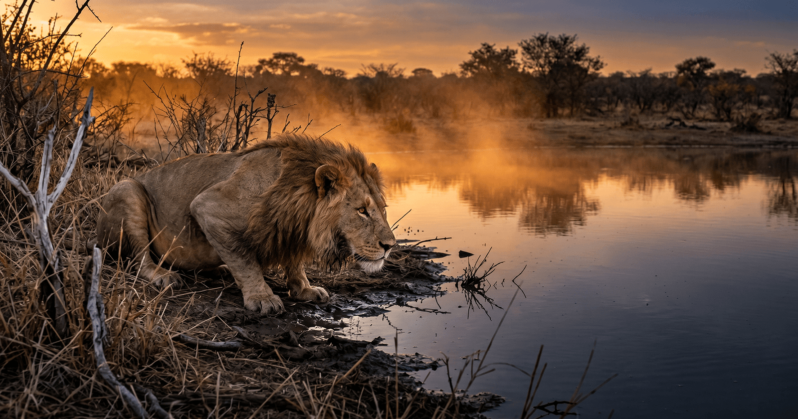
Hwange is a perched ecosystem. The national park sits on a deep bed of Kalahari Sand — ancient, infertile, and almost entirely without surface water for much of the year. Unlike the Okavango, which floods annually from Angolan rainfall, or the Chobe, which draws from a permanent river system, Hwange has no natural drainage. Rainfall disappears through the sand almost immediately. The entire wildlife system of Hwange — and the reason it supports Zimbabwe's most significant large mammal populations — is an artefact of human intervention.
How Hwange's Pumped Pans Actually Work
Pan infrastructure, first established in the colonial era and today managed with solar-powered boreholes, maintains approximately sixty active water points distributed across the park. These are not decorative. They are the ecological load-bearing walls of the entire Hwange system. Remove the pumps and the Kalahari Sand reclaims the bush within a single dry season. The wildlife — the elephants, the lions, the painted dogs, the sable antelope — are there because the water is there. And the water is there because a borehole is there. This matters for a safari guest because it means wildlife distribution in Hwange is not random and not governed solely by seasonal instinct. It is, to a remarkable degree, predictable. A knowledgeable guide with an understanding of which pans are currently active can position you with a precision that open-system parks simply cannot match.
This package's Hwange base — Camelthorn Lodge in the Ngamo Forest Area — provides exclusive access to the Ngamo Plains, a fossil lake bed where the relationship between solar-pumped water and animal orbit is at its most legible. The Ngamo pans attract the Ngamo lion pride, a resident cheetah coalition, and elephant herds that have been observing the waterhole cycle for generations. The lions do not roam Hwange in the manner of a Serengeti cat. They orbit. They track the water schedule. Watch a dominant pride for long enough and you will see not just lions but a hydrological management system expressed as predator behaviour.
The Underground Blind — A Different Conversation with Elephants
At Camelthorn, the standard game drive vehicle is not your only field platform. The Look-out Blind is built at the level of the water surface itself — subterranean, approached on foot, positioned so that the horizon of the pan is essentially eye-level with a drinking elephant's feet.
From a game drive vehicle, you observe elephant social structure from above and at a distance. You see posturing, displacement, the movement of breeding herds around dominant bulls. It reads as behaviour. From the underground blind at the water surface, you see mechanics. You observe the pedal morphology of Loxodonta africana — the way the forefoot spreads under weight on damp sand, the subtle flexion of the wrist joint as a cow steps aside for a bull, the trunk mechanics of deep-suction drinking. You see the sub-surface vibration of sub-sonic rumbling travel through the earth at your eye level. You see dominance not as drama but as physics — shifts of bodyweight, adjustments of ear angle, the almost imperceptible repositioning that means an entire breeding herd of forty animals reconfigures itself around a single arriving bull without a single vocalisation a human ear can detect.
This is field intelligence that a vehicle seat cannot provide. It is also why the Ngamo Plains, specifically, are the most technically rich component of this three-destination itinerary.
The Thirstland: Hwange's Dry Season Concentration Effect
Hwange's most spectacular wildlife viewing windows are counterintuitive to travellers accustomed to East African calendars. The dry season — roughly May through October — is the peak concentration period, not the green season. As surface water disappears from surrounding areas, wildlife contracts toward the borehole pans with increasing intensity. By August and September, pan edges that were quiet in the rains host elephant aggregations numbering in the hundreds.
The Kalahari Sand acts as a funnel. The elevated, infertile, waterless terrain surrounding the park's core water points becomes a biological forcing mechanism. Animals must commit to the pan or leave the system entirely. Most stay, because the pan infrastructure at Hwange is reliable in a way that the broader Kalahari landscape is not.
For a traveller arriving in the dry season, this means daily game drives with a structural predictability unusual in African wildlife systems. You are not hunting for animals across a landscape. You are attending a water point that the animals will reach — because the geology and the hydrology of the system leave them no other choice.
This also explains the painted dog dynamic at Hwange. The park hosts one of Zimbabwe's most significant Lycaon pictus populations, and the Painted Dog Conservation Centre near the park boundary manages one of the continent's most technically sophisticated rehabilitation and range management programmes. Wild dogs require enormous range — a single pack typically covers between 400 and 800 square kilometres — but Hwange's borehole pan network means their prey concentrations are denser and more reliably located than in open-system parks. The dogs adapt to the hydrology. Their denning sites are chosen in relation to pan proximity. Their hunting routes triangulate between water points. The Kalahari Sand system that makes Hwange superficially inhospitable is precisely what makes it ecologically rich.
If you spend time at the Conservation Centre, ask about the GPS collar data. The orbital patterns of individual dog packs around the managed pan system are among the most compelling pieces of field intelligence Hwange produces.
If your interest extends further into Zimbabwe's broader wildlife trophy systems, the Zambezi Valley offers a very different tactical context — our tiger fish fishing guide for the Zambezi River covers the river system's seasonal mechanics from a specialist angling perspective, with relevance to any itinerary that includes Mana Pools or the broader mid-Zambezi corridor.
Victoria Falls — The Geological Overture
The 10-day itinerary opens at Victoria Falls, and the geology of Mosi-oa-Tunya deserves more than the standard tourist framing it typically receives.
The falls are a feature of basalt rock — specifically, of ancient lava flows that created a flat, hard plateau through which the Zambezi has been cutting a succession of gorges for several million years. The current waterfall is not the original. It is the eighth in a series of gorge progressions, each one created as the river finds and exploits a weakness in the basalt fault lines. The Batoka Gorge — visible from the helicopter circuits and microlight flights included in the Victoria Falls activity menu — is not a scenic backdrop. It is a geological timeline. The successive zigzag pattern of the gorges is the physical record of the river's westward migration through the basalt over geological time.
The Victoria Falls Hotel sits in this historical layer. Arriving from the airport — twenty minutes by road — guests pass from the industrial margin of the town into a property that has been hosting travellers since 1904, when Cecil Rhodes commissioned it as the grand terminus of his Cape-to-Cairo railway ambition. The air at the hotel carries the scent of damp earth and frangipani, and below it, always, the sub-bass acoustic vibration of the falls themselves. Locals call it Mosi-oa-Tunya — The Smoke That Thunders — and the name is more accurate than it sounds. The spray plume is visible from thirty kilometres in clear conditions, and at peak flood the roar is audible at the hotel terrace.
The activity context around Victoria Falls extends well beyond the falls themselves. The Flight of Angels microlight and helicopter circuits allow you to read the basalt geology directly — the gorge pattern, the current and historical fall lines, the position of the Devil's Cataract where the next gorge cycle is already beginning. Grade 5 white water rafting in the Batoka Gorge (seasonal — typically July through January when water levels allow) places you inside the basalt canyon itself. The Zambezi river cruise at sunset returns the scale to something human — the African Queen and Ra-Ikane vessels run upstream into the national park boundary, where hippo density in the Zambezi shallows is among the highest on the river's course.
For travellers interested in the Victoria Falls region from a dedicated accommodation and safari perspective, our Elephant Camp Victoria Falls covers one of the area's most technically differentiated lodge experiences in the Zambezi National Park corridor.
Reserve your place on the 10-Day Victoria Falls, Hwange & Chobe Safari
The Geological Shift: From Sand to Clay
The flight from Hwange to Kasane — approximately sixty minutes in the private air charter included in this itinerary — covers one of the most geologically significant transitions in Southern Africa's wildlife landscape.
You leave Kalahari Sand. You enter alluvial clay.
The Chobe River system drains a catchment that reaches into Angola and Zambia. Its floodplain soils are the opposite of Hwange's sand — heavy, nutrient-rich clay and silt deposited over millennia by seasonal flooding. This soil chemistry supports a completely different vegetation community. Where Hwange is characterised by mopane woodland, Acacia scrub, and open sand savanna, Chobe produces dense riverine forest, lush floodplain grass, and a permanent water table accessible to vegetation roots year-round.
The practical effect of this soil transition on wildlife is dramatic. Chobe's elephant population — estimated at around 50,000 animals within the national park and surrounding areas — represents the highest density of African elephants in any terrestrial ecosystem on Earth. They are here not because Chobe is exclusively their domain, but because the clay-supported vegetation provides year-round nutrition that the Kalahari Sand cannot. Elephants are ecological engineers. At Chobe, they are working in overdrive — toppling trees, widening channels, creating clearings that secondary grazers exploit. The entire riverine ecosystem is shaped by the interaction between elephant engineering and the alluvial soil chemistry that supports the vegetation those elephants consume.
The river safari perspective from Chobe Game Lodge — the standard afternoon and morning boat activity — provides the most direct access to this ecological dynamic. From the water, you observe elephant herds entering the Chobe River at the floodplain edge, swimming deeper than most guests expect, crossing to the Namibian sandbanks and returning. You observe buffalo herds of three and four hundred animals moving through the floodplain grass at the edge of the clay plain. You see the consequence of alluvial fertility — not as a botanical fact but as a daily congregation of mammals at numbers that would be impossible in a Kalahari Sand system.
Chobe Game Lodge — The All-Female Guiding Context
Chobe Game Lodge occupies a historically significant position on the Chobe riverfront — it is the oldest tourist facility in Botswana and sits on the boundary of the national park. The Luxury Riverfront Rooms face directly onto the floodplain, and in the dry season the elephant activity visible from a room terrace in the late afternoon often makes a dedicated game drive feel almost redundant.
The lodge's guiding team — the Chobe Angels, an all-female guide cohort — carries its own field intelligence value beyond the marketing angle it typically receives. Female guides in African wildlife contexts bring observational methodologies shaped by different training priorities. The Chobe Angels are specifically trained in river and floodplain ecology, and their briefings on the elephant congregation mechanics and the alluvial vegetation cycle tend to carry more systematic ecological depth than standard game drive commentary.
The cool, humid microclimate of the Chobe riverfront is a physical contrast to Hwange's parched Kalahari air. The soundscape shifts accordingly — the dry-season silence of Hwange, broken only by the metallic smell of water hitting hot earth at a pumped pan, gives way to the perpetual vocal presence of hippos, the liquid calls of fish eagles, and the low golden-blue evening light that reflects off the floodplain surface in a way unique to river systems.
The Value of Private Air
This itinerary's logistics are built around private air charter between all three hubs — Victoria Falls to Hwange (45 minutes), Hwange to Kasane (60 minutes). On the surface, this is a comfort argument. In field intelligence terms, it is a more significant distinction.
Road transfers in this corridor range from four to six hours at minimum. The Hwange-to-Kasane road transfer, in particular, crosses terrain that offers no meaningful wildlife observation value and arrives at its destination too late in the afternoon for productive game drive timing. Private air means that your first afternoon game activity at each destination begins at peak wildlife activity time — golden hour, with full energy, in fresh field condition. The alternative is arriving in the heat of the afternoon, dust-covered, with the best light of the day already gone.
The itinerary's traversing rights compound this advantage. Exclusive access to the Ngamo Forest Area in Hwange and the Chobe National Park riverfront in Botswana means that the game drive activity does not compete with public vehicle traffic. You are not sharing a waterhole viewing position with fourteen other vehicles. The field intelligence your guide can deliver to a private vehicle — about individual animal identification, specific behavioural sequences, hydrological mechanics — is qualitatively different from what is possible when a sighting becomes a public event.
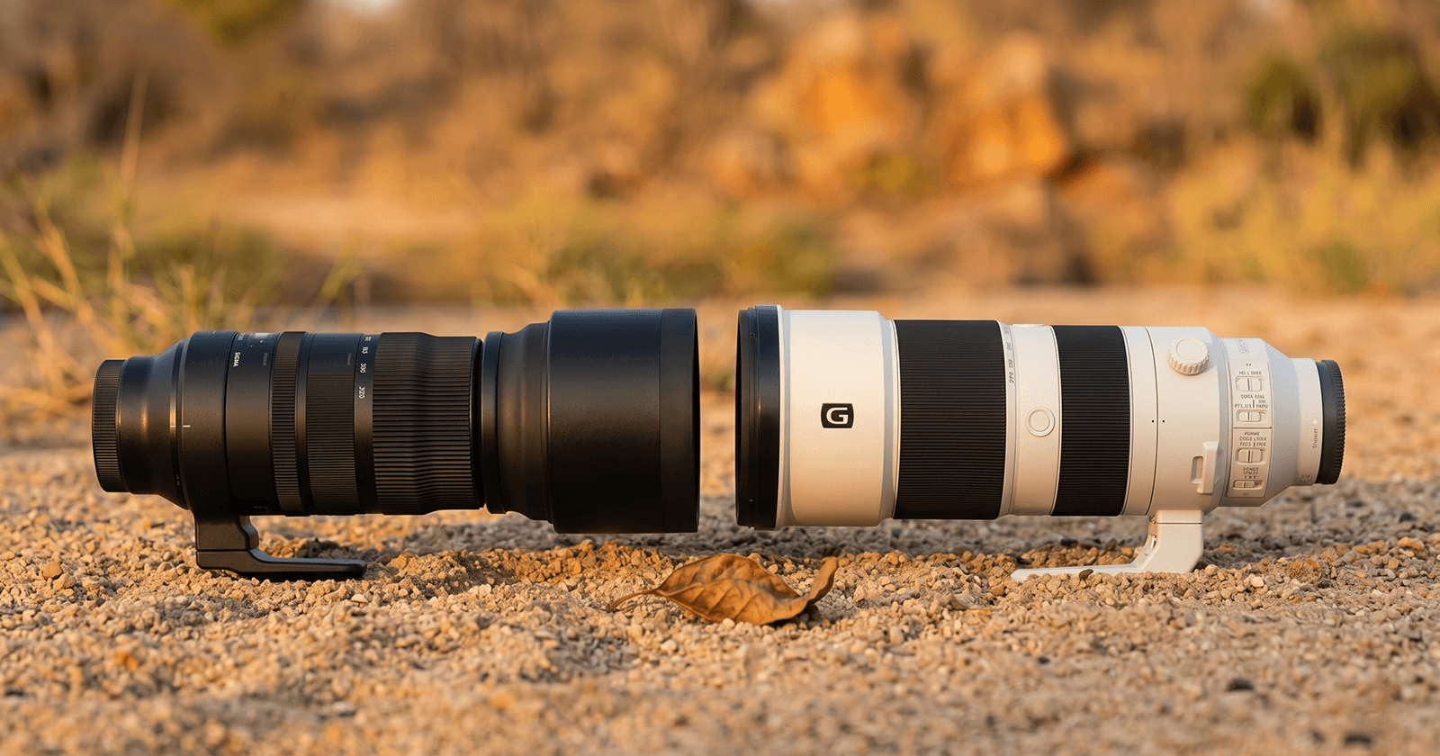
One logistical detail that most fly-in safari itineraries fail to address upfront: private light aircraft in this corridor operate with strict luggage limits, typically 15 to 20 kilograms per person in soft-sided bags only. Hard-shell cases and rigid camera cases cannot be accommodated in the luggage holds of Cessna Caravan or similar bush aircraft. Photographers travelling with a telephoto lens setup — a Sony 200-600mm or equivalent — should plan their kit around a single telephoto-capable soft backpack that fits the weight ceiling. Everything else should be distributed across soft duffel bags. Airlines operating in this corridor enforce these limits at check-in without exception. Arriving at Victoria Falls Airport with hard luggage and expecting it to travel on a bush charter is one of the most common and most avoidable logistical failures in Southern African fly-in safari planning.
What the Standard Alternative Misses
A standard regional package covering the Victoria Falls to Chobe corridor typically involves road transfers, public-access game drives in high-traffic areas, and accommodation in town hotels rather than purpose-built wildlife properties. The experiential gap between that option and this package is not measured in comfort — it is measured in field intelligence access.
The pumped pan system of the Ngamo Plains requires a guide who works it daily to read correctly. The underground blind requires a property that has built it and maintains it. The Chobe riverfront requires a time-in-seat position that an afternoon arrival after a road transfer cannot provide. None of these advantages are available in a standard alternative. The comparison is not between better and worse versions of the same experience. It is between a surface-level encounter with the landscape and a technically differentiated understanding of why the animals are exactly where they are.
| Feature | This Safari.com Package | Standard Regional Alternative |
|---|---|---|
| Hydrology focus | Strategic pumped pan access — Ngamo Plains | Standard public waterhole routes |
| Wildlife viewing perspective | Underground water-level blind at pan surface | Standard elevated 4x4 only |
| Guiding quality | Private specialist guides — Ngamo exclusive access | High-turnover lodge-trained staff |
| Logistics | Private air charters between all three hubs | 4–6 hour road transfers |
| Victoria Falls stay | Iconic Victorian-era landmark property | Modern 3-star town hotels |
| Chobe access | Dedicated riverfront lodge — all-female specialist guide team | Public boat safari and park day trips |
People Also Ask
Is it better to see Victoria Falls from the Zimbabwe or Zambia side?
Both sides offer distinct vantage points, and which is "better" depends on the water level at the time of your visit. The Zimbabwe side generally provides the wider, more panoramic view of the main falls and the full width of the Devil's Cataract. The Zambia side (Livingstone) provides closer access to the Eastern Cataract and the Boiling Pot at the base. At peak flood (February through May), spray from the Zimbabwe side can completely obscure the falls themselves — the Zambia side tends to offer clearer views in high-water conditions. For most visitors arriving in the dry season window of June through October, the Zimbabwe side provides the most visually accessible and photographically productive perspective. Both sides also offer helicopter and microlight circuit access over the gorge system.
What is the best time of year for predator sightings in Hwange National Park?
The dry season from June through October is the peak predator sighting window in Hwange, driven directly by the pan hydrology mechanics described above. As surface water contracts to the managed borehole pans, prey species concentrate predictably at water points — and the predators that depend on them follow. Lion prides in the Ngamo area orbit the active pans in well-documented patterns that specialist guides can read accurately. Wild dog denning season (June to August) also produces higher frequency sightings as the pack reduces its range during the denning and pup-rearing period. The summer months (November through February) bring rain, dispersed water, and correspondingly dispersed wildlife — visibility is lower, but the green season brings calving activity and migrant bird populations for specialist birders.
How long is the transfer from Victoria Falls to Hwange National Park?
By road, the transfer from Victoria Falls to Hwange's main camps takes approximately three to four hours, depending on the specific camp destination within the park. To the Ngamo area — where Camelthorn Lodge is situated — road transfers can approach five to six hours. This package eliminates that logistics problem entirely through private air charter, with a 45-minute flight from Victoria Falls Airport to the Hwange airstrip. The time-saving translates directly to field activity: an afternoon arrival by air allows a full golden-hour game drive at the Ngamo pans on day one. An afternoon arrival by road typically does not.
What are the pumped pans of Hwange National Park and why do they matter?
The pumped pans of Hwange are a network of approximately sixty artificial water points distributed across the national park, maintained by solar-powered boreholes sunk into the Kalahari Sand aquifer. They exist because Hwange's geological substrate — deep, infertile Kalahari Sand — does not retain surface water. Without the pan infrastructure, most of the national park would be uninhabitable for large mammals during the dry season. The pans were initially developed under colonial park management in the mid-20th century and have been maintained and expanded since. In ecological terms, they function as a hydrological prosthetic for a system that would otherwise lack sufficient water to support its wildlife populations. For safari guests, they create the concentrated, predictable wildlife viewing that defines the Hwange experience. The Ngamo Plains pans in Camelthorn's exclusive concession area are among the most productive in the park.
Can you see the Big Five in Chobe National Park?
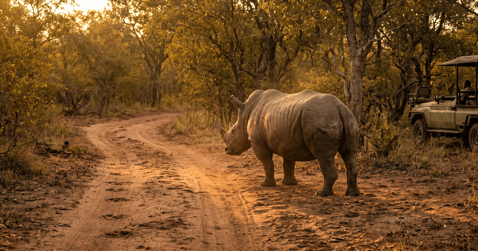
Chobe is confirmed Big Five territory, though the wildlife experience skews strongly toward elephant and buffalo due to the park's exceptional alluvial floodplain productivity. Elephant sightings at Chobe are effectively guaranteed during a multi-day visit — herd sizes commonly number in the hundreds, particularly along the riverfront and Sedudu Island channel. Buffalo herds on the Chobe floodplain regularly exceed 300 to 400 animals. Lion are present and regularly sighted, particularly in the Savuti channel area and the Linyanti region. Leopard are found in the riverine woodland fringe and require dedicated tracking effort. Rhino are not present in Chobe — for rhino sightings, the Greater Kruger ecosystem and Hluhluwe-iMfolozi Park in KwaZulu-Natal are the most productive options in Southern Africa.
Specialist Intelligence Comparison
| Criterion | This Package | Standard Regional Option |
|---|---|---|
| Geological context | Three-ecosystem transition — Zambezi basalt to Kalahari Sand to Chobe alluvial clay | Single-environment access |
| Pan hydrology access | Exclusive Ngamo concession — specialist guide, known pan schedule | Public park access — no concession advantage |
| Underground blind | Camelthorn water-level blind — unique regional perspective | Not available |
| Elephant density insight | Chobe floodplain clay-soil mechanics explained in field context | Standard species count |
| Air logistics | Private charters throughout | Road transfers — 4 to 6 hours each leg |
| Wild dog access | Painted Dog Conservation Centre — rehabilitation programme detail | General park access |
Book the 10-Day Victoria Falls, Hwange & Chobe Safari
Three geological systems. Ten days. Field intelligence that no booking platform briefing will give you before you arrive. This itinerary covers the full ecological arc from the basalt gorge of the Zambezi to the clay floodplains of the Chobe — and the specialist infrastructure at each stop is built to make that geological story legible in the field. Private air throughout. Underground pan blind at Hwange. Riverfront access at Chobe. The Ngamo Plains ecosystem explained by a guide who works it every day.
Krantz Outdoors is a specialist pan-African safari research publication. Our editorial team aggregates field intelligence from professional trackers, wildlife photographers, and conservation scientists to deliver technically verified safari briefings.
This article is compiled from operator specifications, verified field reports, and specialist photography research. Krantz Outdoors conducts independent editorial review of all promotional content.
Affiliate disclosure: This article contains affiliate links. If you book through our Safari.com, Krantz Outdoors may earn a small commission at no additional cost to you. We only recommend experiences we genuinely believe in.
Wild by Nature. Africa by Choice.
Read our Privacy Policy and Terms & Conditions